Moosehead Lake is the largest lake contained within the borders of a single state east of the Mississippi River and what a sight it is. First off, I would like to thank everyone for all the information that they provided us before the trip, along with the great folks at the Lily Bay State Park Campground for their hospitality and their awesome facilities. I would also like to thank everyone at Auntie M's, The Rod and Reel and The Black Frog in Greenville for the great food. If you are planning a trip around Moosehead and need a place to leave your vehicle, you can make arrangements at the Lily Bay State Park office to leave you vehicle at one of the two boat ramps there. There is a small, per person, per day fee for doing so.
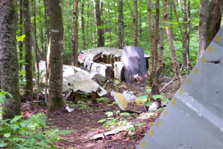
We arrived at the campground late in the afternoon on June 29th. Because there is a 2-night minimum stay on weekends, we had to change our plans a little bit. We originally wanted to stay just for the night of Friday the 30th, but with the 2-night minimum Thursday and Friday would have to do. This worked to our advantage, giving us an extra day to explore the area. We drove by a small sign with a plane symbol and the words "B52 site" several times before we realized what it meant. Thinking back on some of the research that I had done prior to the trip, I remembered something about a B52 that had gone down in the area some time ago. If you are heading north along Lily Bay Road the sign will be on you right, just a few miles south of the state park. We followed a logging road for about 6 1/2 miles to Elephant Mountain, where the crashed occurred. We only had to walk a few feet before we started seeing pieces of the wreckage. Most of us have seen plane crashes on television, but to see one first hand has left a lasting impression on myself. It was hard to believe that all those small shreds of metal were at one time a mighty bomber.
The actual trip around the lake started on Saturday morning, July 1st. We doubled checked all of our gear, leaving behind items that were not necessary. The clothing and food were carried in waterproof bags manufactured by Seattle Sports and the rest of the gear filled just about every cubic inch of space that was available in the kayaks. We headed east on Lily Bay towards Mathews Cove, Mud Cove and then followed the eastern shores of Lily Bay towards Carleton Point. This area is developed, but not as extensively as in some other areas that we would travel through over the next eight days. For the better part of the day, we had encountered light winds and fairly calm waters, however we would soon experience a sudden change. After rounding Hyde Island, we started to notice an increase in the winds. To the northwest we could see a heavy cloud bank from which rain was falling. We had kept abreast of the weather the entire day, so we knew that the was a chance of a few storms over the next couple of days. We were about 1 mile northwest of Hyde Point when we experienced a little bit of what the lake was capable of; 3 to 4 feet waves along with a rain that was driven by strong winds from the northwest. I believe there were a few 5 footers thrown in just for laughs. It is the sudden changes in weather and water conditions that make this lake "not suitable" for beginners to venture out on without being accompanied by an experienced paddler. After battling the waters for about a mile, we found a cove just south of The Narrows to land the kayaks and take a breather. From there we continued our journey towards the campsite on Fox Island in Spencer Bay. When we arrived at Fox Island, early in the evening, we found the campsite occupied. Now it was time for "Plan B"; "Plan B" was to find a suitable area in the woods to set up camp for the night. We turned the kayaks southward towards an area that looked promising and after traveling the shores for a short distance, we located an old road where we set up camp for the night.
The second day started out damp and cool; the forecast was for severe storms developing in the late morning. We decided to keep the camp set up and wait the storms out. At the very least, we would have a dry place to take cover in should the weather take a turn for the worst. Eleven am rolled around and nothing was happening weather wise, so we decided to head out on to the water. The rest of the day was spent paddling Spencer Bay, stopping on the north side of The Narrows to set up camp for the night. Spencer Bay will offer a peaceful paddle with very little power boat traffic; it is also prone to winds out of the southwest. Because of the late start that morning, we only managed to travel a total of 13.9 miles on day two of the trip. The third day started off early; everything was packed up and ready to go by 8:30. We managed to make up most of our lost ground from the previous day. After exploring Cowen Cove it was off to Mount Kineo. Although Mount Kineo is by no means a very tall mountain, it was impressive to paddle up to the base of it ledges on the east side. Mount Kineo rises 1,789 feet above sea level and by White Mountain standards it is just a hill. With its 700+ feet shear cliffs that rise above the lake, you are able to paddle right up to the base of the mountain on the east side. The notable thing to mention about this area in regards to safety is the boat traffic. The central area of the lake is what I would call "heavily developed" with a large amount of boat traffic. When traveling through this area always pay attention to your surroundings. This is one of the most popular "get away spots" on the lake and tour boats leave the docks from the peninsula, just west of the mountain, on a regular basis. We reached a beautiful area known as Big Duck Cove late in the afternoon and decided to stop there to set up camp for the night.
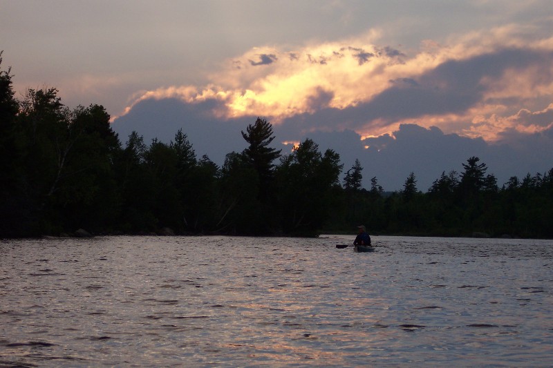
We awoke on the morning of July 4th to the sound of rain on the tents, so we decided to sleep in while until the rain pasted. Although we only had to stop once for a storm, the winds remained fairly strong for most of the day, with a late start and less than perfect paddling conditions, we still managed to make it to the north end of the lake, just shy of the halfway point. As we paddled towards Northeast Carry, we noticed an increase of the number of camps and homes along the lake. For myself this was a little disappointing; I was expecting fewer homes as we approached the northern most reaches of the lake. Despite the homes and camps, this is still a beautiful area of the lake. The weather once again turned rainy in the afternoon, but it still did not dampen our spirits. By days end we had reached the campsite on Seboomook Point and managed to get the tents set up between the rounds of showers. This was one the most scenic sites that we stayed at during the entire trip, although the other sites also offered us great views of the surrounding area. The rock ledges along the water of Seboomook Point make for an awesome place to unwind, relax and enjoy the views of lake to the south. By 9 pm the weather had settled down around Moosehead Lake; most of the remaining storms in the area stayed to the north around Chamberlain Lake and the Allagash Wilderness Waterway.
The morning of July 5th broke without the sound of rain on the tent flies. We paddled our way up into Northwest Cove and past the small village of Seboomook in the northwest corner of the cove. This area of the lake offers no place to set up camp because most of the land is either privately owned or developed. By noon we had made our way around Northwest Cove and was finally heading south along the western shores of the lake. So far, we had not seen a single moose along the lake or in any of its tributaries, however, we did spot a few (or maybe one, several times) Bald Eagles along the eastern shores. Loons and Common Mergansers can be found almost anywhere on the lake. After reaching the Williams River, just north of Ogontz, we decided to do a little exploring and take a side trip up the river. This area is very scenic and should be on your "places to visit" list if you are planning a trip to Moosehead Lake. After our short side trip, we continued southwards towards Moose Brook. Travel was good, but there were no campsites to be found along this stretch of lake. After reaching Moose Brook we decided to head east across the lake, back to Big Duck Cove where we had set up camp two nights prior. As we approached the eastern side of the lake, the winds once again picked up, churning the water and making for an interesting paddle. On the morning of July 6th, we headed back across the lake to pick up where we left off the night before at Moose Brook. By noon we had reached Socatean Stream, a popular location for moose watching. After paddling a couple of miles upstream, we stopped for lunch and to stretch our legs for a while. This was not the best time of day to spot moose along the stream, so our "mooseless" streak continued. As we approached the Mount Kineo area of the lake, the shorelines once again became lined with homes and camps. In order to make it back to Lily Bay campground on Sunday, we needed to reach a camp site just south of Borrows Cove. After reaching the area the camp site was supposed to be located, we found nothing but some new homes. While my friend and I were taking a break just south of the "missing camp site", a local resident that was out for walk stopped and chatted with us for while. I asked about the missing camp site and she told us that the land had been sold and the camp site eliminated. There is a real need to protect what open land is left around this lake; the southern, mid and northern sections reminded me of Lake Winnipesaukee here in New Hampshire because of the number of homes along the shores. By the end of the day we had made it to another camp site on an un-named island in Lamb Cove, just west of Sandbar Point, There we had an incredible view of the setting sun and very comfortable place to pitch our tents for the night.
The next leg of the journey would take us to Moose Island, just west of Lily Bay. We departed our site in Lamb Cove around 8:15 am and headed southward. The weather on July 7th was the best that we had encountered so far during our adventure around the lake, warm and sunny with a light breeze out of the southwest. When compared to the Mount Kineo area of the lake, there are fewer homes along this section of shoreline and the camp sites are few and far between. The scenery was typical of Moosehead Lake; beautiful and serene. We arrived at the camp site on the northern tip of Moose Island late in the afternoon only to find it occupied or so we thought. The next closest site was on eastern side of the island, just a mile or so away. We located the site after a short paddle down the eastern side of the island, only to find it too was occupied. The last site in the area that was shown on the maps was located west of the island, along the Middle Squaw Brook. It was now starting to get late, so this became our best option without having to paddle several miles to the other side of the lake. After paddling a short distance up the brook, we realized that this site must have gone the same way as the one we were looking for the day before. We headed back to the site on the northern end of Moose Island, hoping that there would be enough room to set up for the night. After arriving at the site, we found that two more tents had been set up along the shoreline. As we approached, a gentleman greeted us in broken English and told us that he was just staying one night and there was plenty of room for our tents. As it turned out, the tents we spotted earlier had been abandoned and the gentleman and his son were the only two actually staying there that night. The two were from Canada and were spending their last night on the lake after traveling the last thirteen days touring the lake by canoe. It was the first time during the entire trip we had a chance to meet someone else that had set out to paddle the entire lake. Their intensions were pretty straight forward; to paddle to the north end of the lake and back. Our plan was to paddle the entire circumference of the lake in nine days. This was not the first trip on the lake for the gentleman from Canada; he told us several stories of past trips and gave us a few pointers when traveling Moosehead. The most important tips were to be prepared for any weather condition and the cold waters. Like most of the large lakes, the water conditions on Moosehead Lake can change in a moments notice. The camp site on Moose Island appeared to be less maintained then the others we had stayed at over the prior seven days and a short walk up a road that ran through the middle of the island explained why. The trees were marked with oranges tags, indicating that the land had been recently surveyed and sub-divided. It was clear that the land was under development, which is sad to see. The night of July 7th would become the most interesting night we spent on the lake; not because of the scenery, but because of the of a very unusual event that would unfold around 11:30 pm. I had been sound asleep for almost two hours at this point and has everyone knows your brain does not function like it should when you are awakened suddenly. My friend had set his tent up just a short distance from mine on the same road that cut through the middle of the island. He was apparently awoken by the site of lights on his tent. His first instinct was to think that there was a vehicle coming down the road, on a collision course for our tents. He woke me up with the words " Rick. wake up! There's a car coming down the road and it is going to hit us!". Well, the first thing you do when you are awakened like that is to get out of the sleeping bag and dive for the exit, which I did. It only took a few seconds for my brain to wake up and say "wait a minute! We are on an island; how can there be a car coming down this road! It Turned out there were a few folks in a boat looking for a place to camp for the night and they had turned their spotlight on to our tents. At the time it was not too funny, but now all we can do is laugh about it.
The morning of July 8th rolled around without rain and cars traversing the road we had camped on. After getting an early start, it was to be the last full day of paddling on the lake, this day has become known us as the "Greenville loop" part of the trip. The folks from Canada awoke about the same time we did. Needing to return their rented canoe in Greenville by noon, they headed out onto the water before us. We left the site about a half hour or so later, heading south towards Greenville along the eastern side of Moose Island. As we approached the town of Greenville, we turned around to view the lake to the north. It was hard to believe that we had almost gone full circle and that the trip was nearing an end. We stopped to stretch out legs at the public boat launch in West Cove; after which we continued towards Greenville Junction. As we rounded West Cove Point, one of many the sea planes that operate out of Greenville made a perfect landing on the calm waters. The boarding whistle on the Katahdin, a tour boat based out of Greenville, signaled as we started our way back towards Moose Island. Our intentions were to finish paddling the southern end of lake and spend the last night on Moose Island, but if there was alternative place to camp that night, we would take it. As we approached the east side of Moose Island, I spotted what appeared to be a small sign located in a clearing about 7/10ths of a mile east of Bolton Cove on the mainland; definitely something worth looking into. As we approached the area it became clear that it was a Maine Department of Conservation sign; this was land that the state had easement rights on. After considering the circumstances on Moose Island, this area made for a better option. There was just enough open space to pitch a couple of tents, we just needed to clear some of the small branches that were lying around. Being the last night on the lake and having good weather we decided to leave the flies off from the tents to give us view of the night sky. This is something that is only recommended if you are absolutely certain there is no chance for rain; talk about a rude awakening.
Sunday July 9th; it will be our last day on the lake. We are now only 12 miles from completing the circle and the plan is to just make it a leisurely paddle back to Lily Bay Campground. We left our site at about 8;15 am and headed north, just west of Burnt Jacket Mountain. As we rounded Burnt Jacket Point, Lily Bay and Mount Kineo came into view. Taking our time, we paddled our way around some small islands near Caribou Point. Suddenly my friend just stopped paddling. We had accidentally stumbled upon a nesting loon. Right behind her, just about completely out of view, was a small, puffy ball of feathers. At this point we didn't want to make any quick moves that would alarm the two, so we kept the paddles low and used short strokes to distance ourselves from the nesting area. In Beaver Cove, just south of Black Point, I had the opportunity to talk to a couple that were out for a short morning paddle. After exchanging greetings, they noticed the gear on top of our kayaks and asked if we had been out camping. I spoke to them about our expedition around the lake and of where we were heading. They then told me of a time when they tried to do a 3-day trip in a canoe only to have the weather take a turn for the worst. After spending 3 days on an Island waiting out the weather, they were finally forced to make their way back because they were running out of food. Canoes do offer the advantage of having more room for gear, but when it comes to handling rough water, kayaks have the upper hand. We completed the circle at about noon when we landed our kayaks at Lily Bay State Campground. At the boat ramp we spoke to a couple that were just gearing up their canoe to head out on the water. It turned out that they were from Philadelphia and summered in the town of Warren, NH which is not too far from where I live in Keene. It is truly a small world. After loading up the truck with all of our gear, I started to reflect on what we just accomplished; 181.7 miles in 8 1/2 days, flat water to large swells, beautiful weather to dangerous storms. This trip will also help us better prepare for other long journeys and it gave me insight on what I can accomplish in the future.
To sum up the trip in just a few words I would say it was awesome, beautiful, adventurous and at times nearly pushed us to our limits. It is not a lake that I would recommend to the novice paddler, at least not without the aid of a guide or an experienced paddler. The lake has many faces, both good and bad; I suspect that we did not see its worst. One minute we would be paddling flat water and the next minute be faced with high winds, large swells and a driving rain. I would do it all again next week if I have the chance.